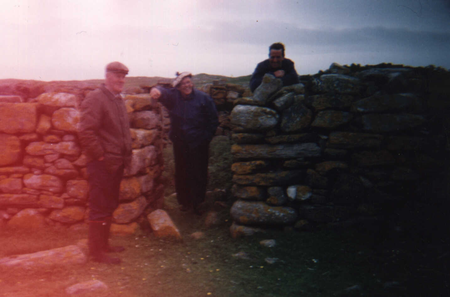
Canadian cousins on Heiskeir
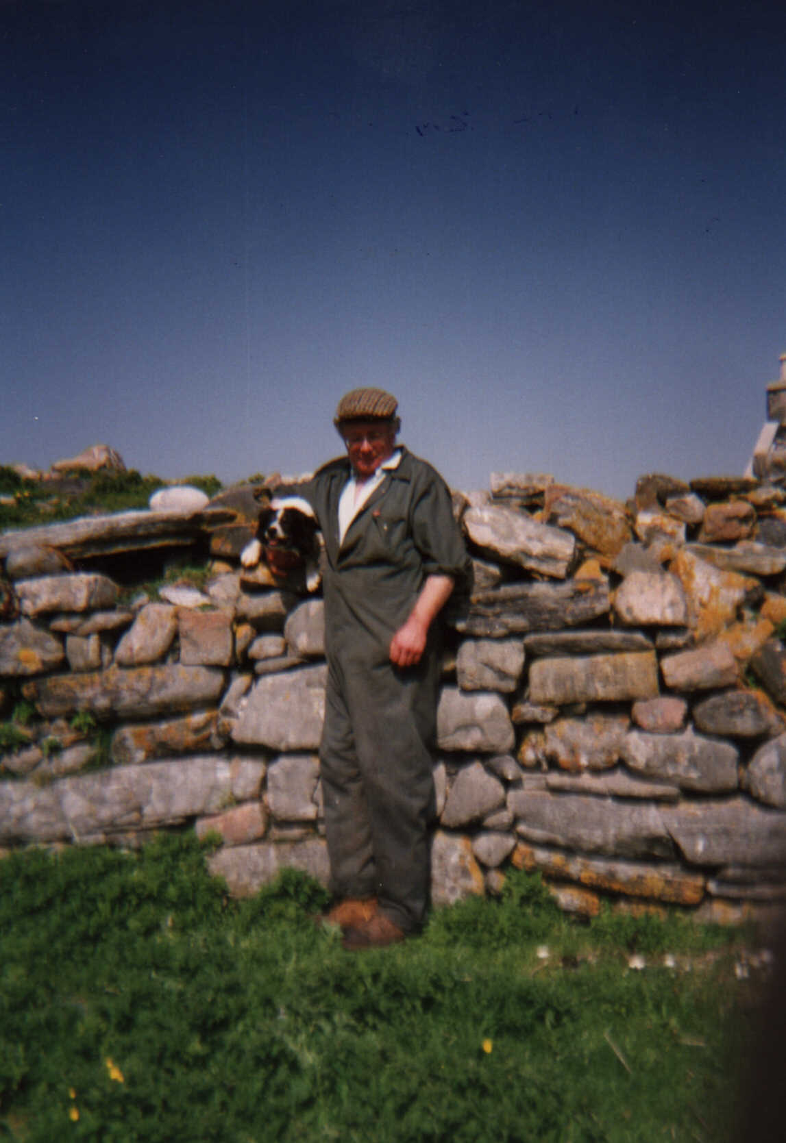
Norman MacAulay (Kirkibost)in Heiskeir 1992
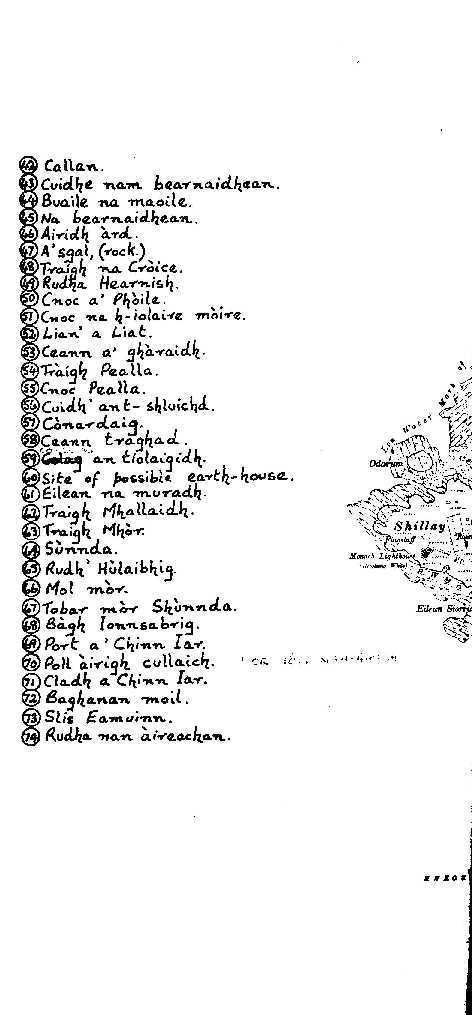
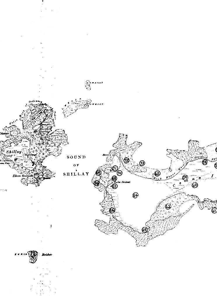
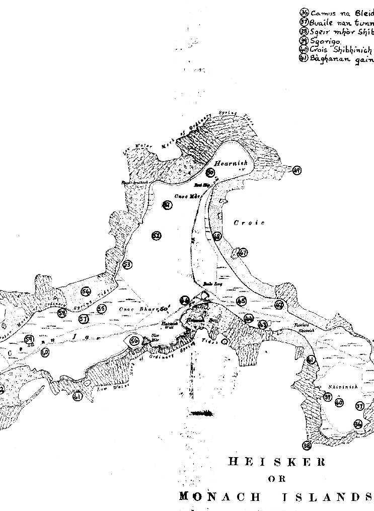
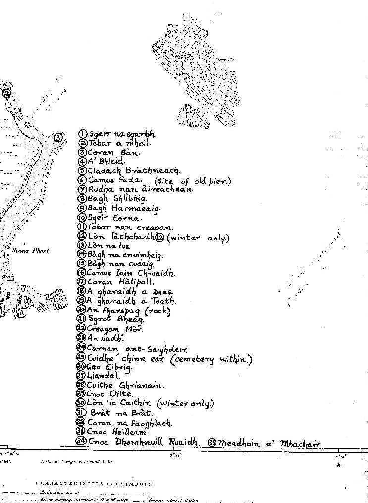
MAP OF HEISKER OR MONACH ISLANDS
For information on family
trees
Canadian cousins on Heiskeir
Norman MacAulay (Kirkibost)in Heiskeir 1992
MAP OF HEISKER OR MONACH ISLANDS
THE FARTHEST HEBRIDES............ALASDAIR ALPIN MACGREGOR
1969
CHAPTER FOUR
The Monach Isles
BEYOND THE Sound of Monach, in the Outer Hebrides, roughly 4½
miles to the south-west of the Rudha Mòr, a headland in the Paible
district of North Uist (of which Inverness-shire parish it forms a part),
lies that cluster of five islands known as the Monach Isles, identified
as Heiskeir by M. Martin, Gent., in his unrivalled account of the Western
Isles, based upon such personal observations and investigations as he made
during his memorable tour of them in 1695. Indeed, the natives of these
parts- of the Uists and Benbecula - usually refer to them collectively
as Heiskeir, which explains why this alternative name is also entered against
them on most maps of this region. According to more than one place-names
authority, Heiskeir is derived from the Norse, hellu-sker, denoting a flat
reef or skerry. This origin seems more akin to the name by which the group
was known in the 16th century than to the word, Heiskeir, as usually spelt
nowadays. Dean Monro, in his Descriptione of the Westerne Isles of Scotland
callit Hybrides--the outcome of his having travelled through most of them
in 1549--refers to the group as Helsker Nagaillon. Various modifications
of this spelling are to be found in a number of subsequent works containing
references to the Outer Hebrides.
One must be careful, of course, not to confuse Heiskeir with Haskeir,
the name applied to two clusters of skerries lying roughly a mile apart
and in the same locality. The venerable Dean alludes to these as Haysker,
"quherin infinit slauchter of selchis [seals] is. This ile perteins to
Donald Gormsone." Blaeu's Atlas (1654) marks these skerries as Helskyr
Egach and Hayelskyr na Meul, and indicates that they were inhabited. They
say in the Hebrides that, centuries ago, a certain recluse named MacCrimmon,
desirous of meditating where he might be removed entirely from the intrusions
of mankind, prevailed upon some North Uist fishermen to land him on Haskeir
with a considerable consignment of food. Half a year later the fishermen
returned to Haskeir to find no trace of MacCrimmon, whose fate to this
day remains a mystery. There are some rude ruins on Haskeir believed to
have formed part of MacCrimmon's habitation, and to which the natives of
North Uist still refer as MacCrimmon's Dyke.
The sea between the Monach Isles and North Uist is uniformly shallow.
From a small boat crossing leisurely on a calm day the sound separating
them, one can follow its floor with ease throughout the entire distance.
At intervals during the last five centuries the sea has made serious inroads
in this neighbourhood. How far the Monachs themselves have actually been
affected in this respect, geological investigation reveals. Many official
documents show clearly that the sea has made several encroachments upon
the land on the west of North Uist, immediately opposite the Monach Isles.
It is probable, therefore, that the same marine denudation has also been
in operation in the case of these off-lying islands, though perhaps more
gradually and imperceptibly. References to the Lost Continent believed
to have linked St. Kilda and the Monachs and the Seven Hunters with the
main belt of the Outer Hebrides are frequent in Hebridean folk-lore and
folk-tales. Allusions to the hunting-ground that intervened between North
Uist and St. Kilda, for instance, are common to the legendary of St. Kilda
and of Harris. When I was living on St. Kilda in the autumn of 1930, immediately
prior to its evacuation, the St. Kildans on more than one occasion entertained
me with their versions of the warrior-woman who hunted between Hirta and
Harris before the sea separated them. In confirmation of those they assured
me, although not entirely relevantly, that stags' antlers had been found
on the summit of Oiseval.
Owing to the sea's encroachments, the valued rental of North Uist was
reduced in 1542 by about three merk-lands. This is borne out by that year's
entries in the Exchequer Rolls with reference to devastation wrought by
the sea somewhere about 1540. That similar encroachments were taking place
approximately two centuries later is shown by the following document, dated
1721, and addressed from North Uist to the Forfeited Estates Commissioners:
"We, the wadsetters, tacksmen, and possessors undersubcrivers attest
and deliver-That in regarde of the extreme povertie reigning amongst the
haill tennants and possesors within the Barony of North Uist occasioned
by a murain in our cattle first in 1717 but more especially this year by
a second murain whereby a great many of our cattle have perished to the
number of seven hundred and fourtie five cows, five hundred and seventy
three horse, eight hundred an twentie sheep...And moreover we attest and
deliver that about Candlemass last the sea overflow'd severall pairts of
the countrie breaking down many houses to the hazard of some lives which
hase impaired the lands to such a degree as its possible it may happen
more and more that they cannot answer to the worst sett in former tymes."
The signatures to this attestation prove that the devastation alluded to
in 1721 occurred along the west and north-west shores of North Uist. The
Monach Isles, named from east to west, comprise Stockay, Ceann Ear (East
Head), Shivinish, Ceann Iar (West Head), and Shillay. Their aggregate area
is under 1,600 acres. Measured from the easternmost tip of the barren skerry
of Stockay to the westernmost of Shillay, they cover a distance of just
under 4½ miles. Except for Stockay and Shillay, they differ from
the other detached groups of islands with which this volume deals in that,
when approached from whichever direction, they present themselves to the
eye, not as islands rock-bound and precipitous in the pattern familiar
to those of us who know the North Atlantic's islands, but with a terra
low-lying and not too firma, consisting of sand-dunes and machars, and
of a number of offshore skerries, many of them little more than awash when
not actually exposed.
Between Stockay and Shillay are the three low-lying islands already
mentioned- Ceann Ear, Shivinish, and Ceann Iar. At low water these are
accessible from one another on foot. Shivinish, the islet situated between,
is really a partially detached portion of Ceann Iar. It is fordable from
Ceann Ear at half-tide. At ordinary high tides it still forms part of Ceann
Iar, but not during the high spring tides. In other words, the Monach group
consists of four islands during high-water or low-water, whereas during
the high spring tides it consists of five.
Ceann Ear is by far the largest. Its greatest length is roughly 2¾
miles: its greatest breadth l¾. Its area is almost double that of
Ceann Iar, easily the next in order of size. After the abandonment in 1942
of the lighthouse on Shillay, the Monachs' remaining population of two,
or perhaps three, resided in what stood habitable of the village on Ceann
Ear, already so deserted and largely tumbledown. The village, which included
a small, Presbyterian mission-hall cum school, consisted of stone buildings
roofed with tarred felt. A resident missionary fulfilled the functions
of teacher and pastor. Thatched roofs had been replaced on Ceann Ear several
years previously; and there remained no more than a vestige or two of the
'black houses' of earlier generations.
Weather permitting, mails were conveyed regularly between the post-office
at Bayhead, in North Uist, and Ceann Ear in a boat owned and sailed by
John and Alick MacDonald, crofter brothers then living together as smallholders
on Ceann Ear, pasturing black cattle there and on Ceann Iar, and cultivating
a portion of the soil in the immediate neighbourhood of their home. The
Monachs became uninhabited when, in September, 1943, the MacDonald brothers
retired to the North Uist mainland.
Except where sandy bays and coves give way to rocks and storm-beaches,
the main islands, so flat in places, have a sandy soil largely in the form
of bent-covered sand-dunes curved and crested by the winds, and much given
over to rabbits. Until about half a century ago, they were renowned for
the tough bent-grass from which were made such articles as mats, ropes,
horse-collars, small poaching-nets, and the heavy baskets and sacks in
which both the natives and their North Uist neighbours conveyed their cereals
and meal to and from the mills on North Uist. So thickly pleated were the
sacks of Heiskeir bent that the weavers of them boasted of their having
been virtually impervious to rain or sea-spray. While sheltering in a barn
on Kirkibost, an island on the west of North Uist, Erskine Beveridge, of
Dunfermline, the archaeologist who purchased the Vallay property in North
Uist at the beginning of this century, watched bent ropes in process of
manufacture. At that time Heiskeir was supplying most of the raw material,
although the inhabitants of North Uist were then beginning to show a partiality
for the bent growing on Kirkibost itself.
On Ceann Ear are two freshwater lochans. That situated in the vicinity
of the village is known in the Gaelic as Loch nam Buaidh, Loch of the Virtues.
Why virtues, one asks, recalling that for centuries it was believed by
the natives to be the haunt of the fearsome waterhorse! Much of the folk-lore
of the Monachs is devoted to the dreaded activities of this supernatural
creature. Ceann Ear's other lochan usually dries out entirely during a
summer drought. On Ceann Ear, moreover, are spots which the natives regarded
as the very special province of the faery folk.
On Ceann Iar is the Monachs' only noticeable hillock. Albeit attaining
an altitude of no more than about 60 feet above sea-level, it is called
the Cnoc Mòr, the Great Hillock - great, of course, when compared
with the low-lying aspect of the rest of the group.
Nobody has lived on Ceann Iar in any permanent way for many, many years,
although the crofters living on Ceann Ear resorted to rude dwellings on
it in the summertime. Nevertheless, there still may be seen on Ceann Iar,
at a spot called Croic, a tottering stone building doubtlessly once occupied.
Erskine Beveridge, in the stupendous work on the archaeology and topography
of North Uist he published in 1911, refers to a large cattle-fold on Ceann
Iar "with a range of seven adjoining huts, these latter serving as temporary
accommodation for the crofters of Ceann Ear". This shows that, as recently
as the opening years of the present century, the inhabitants of Ceann Ear
had their summer shielings on Ceann Iar.
Shivinish's area is small. This islet is joined to Ceann Iar by the
elevated spit of sand and the storm-beach which, as already mentioned,
are fordable except during the high spring-tides. The rockbound channel
between Ceann Iar and Shillay is roughly a third of a mile at its narrowest.
It is fairly deep as Monach waters go - sufficiently so at all events to
permit of the passage of small craft, and to have enabled the Pharos to
anchor close at hand when effecting reliefs, or when replenishing coal
and other supplies at Shillay's lighthouse.
The name, Monach, is said to have originated with Shillay. In olden
times Shillay was known by the Gaelic name, Eilean nam Manach, Island of
the Monks. On Blaeu's map the group is marked Hekskyr na Monach. The lighthouse
on Shillay is believed to occupy the site of an ancient monastic settlement.
Moreover, it is held that on this very spot the monks of old maintained
throughout the night a red beacon to warn the tall sailing ships and the
chieftains' birlinns of danger just as the lighthouse warned their powered
succesors.
One or two references to the Monach Isles suggest their association
with nuns, as well as with monks. George Buchanan, in his history of Scotland,
refers to the group as Helsher Vetularum, "so called, as I suppose, because
it belongs to the Nuns of the Island of Icolumkill" (Iona). l`he Monachs'
connection with Iona is mentioned in Dean Monro's Descriptione and elsewhere.
"Be aught myle of sea frae this isle," writes the Dean, "towarts the west,
lyes ane ile four myle and haff myle braid, laiche maine land, callit Hesker
Nagaillon. It has abundance of corne, and elding for fire, it perteins
to the Nuns of Columnkill."
In an obligation dated 17th March, 1575-1576, allusion is made to an
annual payment for a proportion of the farms of Heiskeir. In this document
Heiskeir is called Halskienagallechie, obviously an attempt at spelling
the Gaelic, Heiskeir nan Cailleach, denoting Heiskeir of the Nuns. The
payment actually was in respect of "the third of the fermes of Halskienagallechie";
and the assessment was "tuentie males grane, and the third pairt of ane
maill''. Payment of the same was due yearly by James McDonuill Growemych
of Castle Camus, in Sleat, to the Bishop of the Isles, "in tyme cuming
to be yerlie maid in Ycolmkyll [Iona] betwixt Petersmess and Beltane".
The male or maill was a measure of grain believed to have been of Norse
origin, and once extensively adopted in the Orkney Islands.
The date of the earliest record of the lands of Monach is doubtful.
Sometime during the 13th century, Donald, son of Reginald, grandson of
Somerled of the Isles, mortified "the Island of Heiskeir to the Nuns".'
(Collectanea de Rebus Albanicis).
However, for genealogical and chronological reasons too complicated
to justify our inquiring into them here, Erskine Beveridge thought one
would be safe in ascribing this mortification to the 14th rather than to
the 13th century. A later reference in the publication just cited, probably
dated about 1500, occurs in the passage describing the sister of Donald
Gallda of Lochalsh as having been "such an idiot that she was sent to Heiskeir,
a remote island, lest she should be seen by strangers, to the care of a
gentleman living there, a Macdonald called Donald Du Maclauchlane". Donald
Gallda's sister was 'sequestrated' on Heiskeir, as was the unhappy Lady
Grange 232 years later, prior to her removal to St. Kilda. Lady Grange
was sent there in the autumn of 1734. From a letter written by her in 1738,
it would seem that, much as she hated Heiskeir, she preferred it to St.
Kilda. "I was in great misery in the Husker;" she wrote; "but I am ten
times worse and worse here." Another reference to Heiskeir's associations
with Iona occurs in an Elizabethan document entitled The Isles of Scotland
and the Dlvlslon thereof, with the Names of the Chieftains, dated Edinburgh,
March, 1595. It mentions "Helsker pertaining to the Nunnery of Icolmkill
20 men".
In 1692, the year after the Massacre of Glen Coe, Alexander MacDonald
(Alasdair Ban Mac lain 'ic Uisdein, to give this gentleman the name by
which he was known to his own generation, and by which he still lives in
the traditions of the Outer Isles) despatched his galley from Heiskeir
to Ballachulish with a cargo of barley-meal to relieve destitution among
that remnant of the MacIans which, having escaped the vengeance of Robert
Campbell of Glen Lyon and his felonious accomplices, had returned to its
charred glen from the refuge of the hills. MacDonald was tacksman of Heiskeir
at the time. His promptitude in rendering this assistance to his clans-people,
said to have saved them from starvation, is still remembered at the telling
of tales in seannachie fashion on winter evenings. That he was able to
send forth such a cargo testifies to the fertility of the Monach Isles.
MacDonald must have been a man of some substance: in 1694, a couple
of years after his generosity to the MacIans, he advanced three thousand
merks to Sir Donald MacDonald of Sleat upon a wadset of "the 10 penny lands
of Heiskeir, the penny lands of Peinmore and Peinnie Trynoid, and the 10
penny lands of Balranald". During the 16th and 17th centuries the wadset
occupied a prominent position in the tenancy of North Uist and the islands
adjacent thereto.
On the question of Heiskeir's fertility annotators appear to be somewhat
at variance. Dean Monro, in the passage already quoted, speaks of its having
an abundance of corn. Martin Martin, referring toward the close of the
17th century to its sandy soil, says that it is "very fruitfull in Corne
and Grass, Black Cattle, and the Inhabitants labour under the want of fuel
of all sorts, which obliges them to burn Cows Dung, barley straw, and dry'd
Sea-ware". The Old Statistical Account, mentioning Heiskeir merely in passing,
describes it as possessing a sandy soil, as yielding very little grass
at any time, and as being of no value except in respect of the small quantity
of grain raised there, and of the kelp-burning carried on along its shores.
Another appropriate reference is Captain Otter's, published about 1885.
"About seventy years ago," he writes, "the islands were covered with good
pasturage, with machirs or sandhills of considerable height. At half-tide
all the islands, except Shillay and Stockay, were connected, as at present,
by a sandy beach, and they were inhabited by eighteen families, besides
cottars, who were able to keep 1,000 head of cattle, sheep, Etc." If this
account be accurate, Heiskeir's population in or about l810 must have been
over a hundred. The number of livestock he gives seems incredible for such
an area, so much of which consists of sand-dunes covered with bent. "About
ten years after" [circa 1820], continues Otter's report, "without any apparent
cause, the whole of the surface of the islands was denuded of soil and
grass, except two very small portions on each end." ( Sailing Directions
for the West Coast of Scotland (1885).)
As a result of this, he tells us, the natives, with the exception of
one family, were obliged to quit Heiskeir, which was now to remain uninhabited
for close on fifteen years, during which time a channel 6 to 8 feet in
width was scoured out on each side of Shivinish.
About 1846, according to Samuel Lewis,(Topographical Dictionary of
Scotland with Historical & Statistical Descriptions) when the population
had fallen to 39, the soil yielded a very scanty pasturage, and but a small
quantity of grain. Whether Lewis actually visited the Monachs, I cannot
say. His references to a scanty pasturage and a paucity of grain would
seem to indicate that he obtained his information from The Old Statistical
Account, rather than by personal observation and inquiry. The suspicion
that at any rate he was familiar with that publication is strengthened
by his concluding remark on Heiskeir: "The isle has hitherto derived its
chief value from its kelp shores."
Be this as it may, the Monach Isles are still noted for their fertility,
as fertility goes in the Outer Hebrides. Their last farm was one of the
last to be worked in accordance with the old runrig system. From a letter
I have by me, written some thirty years ago by Hector MacKenzie, then factor
for North Uist, I see that this farm, at the time of his writing me, was
divided into six full shares. The souming of each was eight cows with followers,
two horses, and twenty-four sheep. For souming purposes two cows were reckoned
to be equal to one horse.
On Ceann Ear in 1886 there were eight crofter and six cottar families,
and a teacher. Its population was 75; and fine specimens of manhood its
male members were, I have been told by those who knew them--big-boned,
deep-chested, alert, and intelligent, few of them under six feet. Their
homes were the abode of the traditional Highland hospitality. Owing to
emigration to Canada so soon afterwards, as also to simultaneous transference
to holdings on North Uist, to which the islanders always referred as 'the
mainland', population fell steadily. By the mid-1930s it had dropped to
17, made up of three crofter families, one cottar, a teacher-missionary,
and the three keepers manning the lighthouse on Shillay.
Well into the 1930s the inhabitants' fuel was peat. A grand sight in
olden times were the Monach smacks leisurely ferrying home the peats. During
the month of August these smacks might have been seen lying off Dusary
and Claddach Kyles, and at a place appropriately called Ardheiskeir. The
peats were cast on the moor of Kyles Paible, on the west side of North
Uist, and also on certain allotted bogs fringing both sides of the Committee
Road. This is the name given to the road running a distance of four miles
between Malacleit and the Vallay Strand, in the north, and Dusary, in the
south, facilitating a shortcut across the north-west portion of North Uist.
It was constructed about 1846 with a view to providing a measure of employment
during the widespread distress consequent upon the Potato Famine.
Some years prior to the Second World War the inhabitants of the Monach
Isles began to burn coal instead of peat. This reached them by the puffer
arriving periodically with supplies for the lighthouse on Shillay. On Heiskeir
as elsewhere, the use of coal soon led to the introduction of a convenient
type of American stove. Mention of fuel reminds one of the natives' having
informed Martin that bread baked by the fuel of seaware relished better
than bread baked by ally other means. At that time they were in the habit
of salting their cheeses with the ashes of barley straw "which they suffer
not to ly on it above 12 hours time, because otherwise it would spoil it".
The Heiskeir crofters were always regarded as among the most prosperous
in the Hebrides. In addition to lobster-fishing, kelp, and the making of
tweed, they were renowned for their black cattle and sheep - from a butchery
point of view, of course! Well into the present century, large quantities
of tangle ash and also of kelp were produced. Owing to declining man-power,
this lucrative home industry had to be abandoned. No kelp has been exported
from Heiskeir since 1926.
Superficially at all events, the Monach Isles are almost entirely devoid
of archaeological interest. In this respect they are very different from
the Uists, which are so rich in ancient duns and castles, chambered cairns,
barps, cells, chapels, earth-houses, standing-stones, stone-circles, ecclesiological
remains, and the like. Martin, however, does mention a stone chest discovered
there, "having an earthen Pitcher in it which was full of Bones, and so
soon as touched they [ ] to Dust)).
In July, 1906, Erskine Beveridge came upon a kitchen midden of shells
and ashes near the north-west corner of Ceann Ear, hard by a cist with
human bones exposed by the shifting sands, and also another large midden
of limpet shells toward the north-east of the same island. Two hammer-stones
were discovered about this time on Ceann Iar. Beveridge expressed the opinion
that the Monachs' sand-drifts probably conceal much evidence of pre-historic
occupation. One or two authorities speak of the existence of ancient crosses.
The New Statistical Account, for example, refers to several crosses rudely
cut in stone such as are found in burying-grounds, "particularly on the
island of Husker".
Long ago there resided on Ceann Iar a couple of ravens that would not
tolerate the approach of any of their species. Immediately a stray raven
came in sight, this couple drove it off "with such a noise as is heard
by all the inhabitants". It was said that, as soon as its own young were
able to fend for themselves, they were driven forth in like manner. One
of the couple, wounded by gun-shot, was forced to shelter for some weeks
in a cleft among the rocks, during which time its mate daily brought it
provisions. When eventually the female died, the surviving bird left Ceann
Iar, returning a few days later, accompanied by about a dozen of his own
feather. Subsequently, he selected from this number a new mate, after which
the others departed, leaving Ceann Iar once again in the possession of
a pair of their species. If at any time a carcass lay on the fields, or
had been cast ashore on any of the Monachs, the natives declared that they
were able to distinguish by the ravens' noise whether it was flesh or fish.
When Martin told the islanders that he scarcely credited this 'nicety',
they replied that they could vouch for the accuracy of this statement from
personal observation, adding that the ravens were always noisiest when
the carcass was flesh.
The channel in which the natives used to catch seals is undoubtedly
that separating Ceann Iar and Shillay. In olden times they caught them
in nets they themselves had made of several horse-hair ropes. The most
famous place for sealing in this locality was, of course, Cousamul, that
sprinkling of skerries lying roughly six miles due north of Ceann Ear.
To the annual raid upon the seals at Cousamul, boats used to go from places
as distant as the crofting townships near the Butt of Lewis.
In the days before the erection of the lighthouse on Shillay, the natives
pastured sheep on that island. There came a day-so the story has it - when
most of them, men and women, went over the sound to the shearing of the
Shillay sheep. The men were not long at their task when they yielded to
the temptation to raid the seals on a neighbouring skerry. But they had
failed to secure their boat, with the result that it drifted well beyond
reach by the time that a flowing tide began to encroach upon this skerry.
Frantic with despair for the safety of their menfolk were the Monach women
as they watched from Shillay the surging flood-tide encompassing the sealers.
Their piteous cries at length were heard by a woman on the North Uist shore.
Unaided, she launched the only boat available. Alas! her effort was in
vain. The tide had swept Monach's men-folk to drowning long ere she could
reach the skerry. Many in the Outer Hebrides were convinced that this fatality
was a judgment upon the people of Monach, since they believed the seals
to be human beings, under enchantment. The Seal-folk, one recalls, are
emissaries from the Courts of the Kings of Lochlann, under spell.
When staying at Lochmaddy shortly before the outbreak of the Second
World War, I set out for the West Side by way of West Ford Inn and Claddach
Kyles and Claddach Kirkibost, arriving in due course at a tiny place called
Bayhead. Diverting there from the main road, I lingered through the wild
flowers about Balmore and Knockantorran until I reached the shore at Maskeir.
Out in the Atlantic lay the Isles I was anxious to visit. As I sat a-dreaming
among the waving marram and the grasshoppers, I suddenly noticed afar off
the Monach boat, sailing toward the customary landing-place among the rocks
at Maskeir. I could see that she was a boat with only one mast and a fairly
large sail. Only one mast, I remark, because the Monach boats usually had
two, each designed to carry a canvas somewhat smaller than that associated
with a single-masted boat of similar draught and dimensions. The Monach
seamen used to maintain that, in the event of a squall overtaking them
during the passage between Fort Roy and North Uist, they could always handle
with confidence a boat having two masts and two smallish sails.
All the world this day seemed radiant with the sun's light and warmth.
Mirrored in a still sea were the mountains of South Uist. Away to the right
of them lay the Barra Isles, seen as if through a purple gauze separating
faeryland from the full gaze of men. Barra itself and distant Mingulay
dwarfed the other islands so closely associated with them. To the east
of me lay Benbecula and the Great North Ford, the latter at this range
appearing to run up to the base of the mountain called Eaval. Far beyond,
and without the faintest vestige of a cloud upon them, were the Coolins
of Skye. One picked out afar three islands of the St. Kilda group - Boreray,
Hirta, and Dùn. The steep precipices of Conachair and the Bioda
Mòr stood out with a clearness truly dramatic.
Despite a canvas virtually windless, the Heiskeir boat continued to
approach at a steady pace. Every now and then she was completely obscured
by the offshore reefs. I knew pretty well how long it would be ere she
set sail again for Port Roy, aware from experience of such settings and
conditions that the Monach men would have several matters to attend to,
and cargo to take aboard. The prospect of my returning with them later
in the day seemed reasonably good. In anticipation of so fortunate a contingency,
I already had deposited at a spot easily found among the sand-dunes the
few things I would require.
While the Monach men landed to wander leisurely through the fields
to the post-office at Bayhead, I likewise took to wandering. In so doing
I came upon a cart-track winding through the machar where, in places, wheel-ruts
lay hidden by wild flowers at a depth of more than 18 inches: so overgrown
is this track in the summertime. It soon led me to a tiny homestead at
Paiblesgarry, encircled by hayricks, and corn but half ripe. Here I asked
for food, since hunger was now upon me, and I already had tramped many
a good mile to reach the West Side and the Heiskeir ferrying-place. Soon
I returned from Paiblesgarry to the shore. There I found a flat-bottomed
dinghy drawn up among the rocks, waiting, as I hoped, to ferry me in due
course to the Monach boat now anchored about fifty yards offshore, and
shortly to return to Ceann Ear. By invitation I stepped aboard, and in
less than an hour disembarked at the landingstage among the rocks at Port
Roy. When sailing in by Stockay, we overhauled a small craft containing
three Uist fishermen engaged in drawing in flounders on lines with greater
rapidity than the disciples ever did on the Sea of Galilee in the days
of miracles. The sandy sea-floor off the Monach Isles, especially that
stretch of it between Ceann Ear and North Uist, abounds in flounders. A
native informed me a day or two later that, on a line of 400 hooks, he
often had caught as many as 360 within a couple of hours. Seals innumerable
were now swimming off the skerries on every side of us, heedless of our
proximity.
The day was calm and warm. Lobster-fishermen from Grimsay and Benbecula,
just returned from visiting their pots, lay sleepily on the scented grass
above the shore, their boats meanwhile riding at anchor or attached to
moorings in Port Poy's sunlit harbour. Grimsay, an isle approximately 20
miles from Port Roy, is renowned for its boat-building. Indeed, all the
Monach boats at that time, and also those from which lobster-men still
exploit these waters, were built there. The boat in which the natives passed
to and fro between Heiskeir and West Ford Inn or Maskeir was built at Kallin,
on Grimsay.
I walked along the path leading through Ceann Ear's fields to the house
of the MacDonalds, with whom I now had been invited to sojourn. And I must
confess that not in all my experience of the Outer Hebrides had I seen
better corn and barley and potato crops than here. Small wonder Heiskeir,
when inhabited, had a reputation for fertility! From its rewarding tilth
I lingered thigh-deep through its acres of wild flowers and clover, among
bees and butterflies and purple moths, all of them enjoying the profusion
of this Hebrid isle in time of blooming and ripening. Ceann Ear in ways
reminded me strangely of Vatersay, one of the Barra Isles. Here, as on
Vatersay, one finds buttercup and daisy, ragged robin and wild thyme, bedstraw
and clover, vetch and orchid and lady's smock, knapweed and silverweed,
harebell and bird's-foot trefoil, and the tiniest heart's-ease, each and
all striving for a place in the sun.
There is about these lone fragments of the Hebrides a soothing air
of antiquity, an atmosphere ancient and mellow. On Ceann Ear, at the sun's
downgoing, you might have seen an old woman with a shawl wrapped round
her head, her cheeks weather-tanned; and she lingering in her footless
stockings through the island's pastures toward the west shore, carrying
a couple of pails. Had you watched her closely for a moment or two, you
would have noticed her sudden disappearance among the shoreland rocks,
since the islanders' well lay hidden by boulders just within a few feet
of highwater mark. The problem of good, fresh water had been a difficult
one on Ceann Ear in a dry season. Yet the island, judging by its many marshy
and messy spots, is by no means deficient in springs. It ought to have
been possible to find a plenteous and reliable supply of drinking water
on Ceann Ear.
The Benbecula and Grimsay lobster-fishermen erect for themselves on
the Monach Isles turf and stone hutments. These they inhabit from the end
of April till late in September. In floating crates moored at no distance
offshore, they keep their lobster catches in readiness for the market.
One of their number told me that during the summer months they despatched
to an agent at Lochmaddy as many as 30 dozen lobsters at a time, and that
in winter they sent them direct to London.
While strolling through the trefoil and the orchids, I chanced to fall
in with the island missionary. He informed me that the population stood
at 22, and that this number would dwindle. All the inhabitants were MacDonalds,
all of whom were related to one another. One felt tempted to inquire whether
any of them would have admitted descent from Neil MacDonald, the 17th-century
native who was subject to the falling of his tonsils at every change of
the moon, a condition that lasted only throughout its first quarter. "This
infirmity," says Martin, "hath continued with him all his days, yet he
is now [1695] 72 years of age." Neil had at Paible, in the person of John
Fake, a contemporary who was always afflicted with a fit of sneezing a
day or two before rain. The greater the sneezing, the greater the rainfall
it prognosticated. So reliable a forecast had his sneezing been over a
period of nine years that the islesfolk nicknamed him the Rain-Almanac.
At the time of this visit of mine, eight or ten children attended the
village school, there to be taught by the missionary himself. Only five
of the village's houses were inhabited: several were quite derelict. "There's
ample room for a much greater population," the missionary naively maintained.
"Even another couple of families," he urged, "would make things easier
for the rest." He had in mind coöperative tasks such as the unloading
of Cunningham's puffer when she lay off Port Roy with a consignment of
coal.
Some years earlier, a small jetty had been constructed among the rocks
at Port Roy. At high water this jetty is completely submerged. What, then,
was the use of it? one might ask. It was built to facilitate the shipment
of cattle destined for North Uist by the Monach boat. The cattle were driven
aboard a couple of hours before high water so that, when the boat reached
the other side, either at Maskeir or at the West Ford Inn, the tide was
full. The same procedure was followed when bringing cattle over to Heiskeir.
Shipped at high water, they arrived at Port Roy with the ebb, just as the
jetty was beginning to show above water.
The Monach folks knew everything about the Elements. Indeed, some of
them adapted their lives to the calculable behaviour of sun, moon, and
tide. They held that, if a new moon were visible within three days of her
birth, the Hebrides would soon be visited by a spell of truly bad weather.
Sometimes two visits to North Uist were possible in a day, depending upon
the state of the tides. This the natives always endeavoured to achieve
when transporting livestock of any kind. In winter the sheep on Ceann Iar
were driven over to Ceann Ear; while the cattle grazing throughout the
summer and autumn on Ceann Ear were transferred to Ceann Iar. Although,
as we have seen, the ford is passable at a low tide, the cattle found no
inducement to wander back until the spring, when water begins to run short
on Ceann Iar, and its grass tends to lose its succulence. The Heiskeir
folks told me that their calves would drink anything, although the rearing
of calves on the Monachs not long before had been regarded as unprofitable,
if not impossible, owing to what they believed to have been the unsuitability
of the islands' water. By way of showing how the calves had adapted themselves
to their environment, they now boasted that those then being reared on
Heiskeir would drink even a pailful o' broth!
Sea-spoil is often cast ashore on Ceann Ear, though not so frequently
as on the strands of Baleshare and Kirkibost, which are more favourably
situated for driftwood and the like washed up by wind and tide. Some years
ago a timber-carrying vessel came to grief in the Sound of Harris. Great
quantities of the yellow pine she carried were cast ashore at Ceann Ear,
to the delight of its inhabitants.
With the exception of the schoolhouse, which faces north, the houses
in Ceann Ear, all of them now derelict, were built to face east. They look
out toward North Uist and Benbecula. Likewise was the small mission-hall,
with its red, corrugated roof. This meant that little sunlight entered
by doors and windows. On my asking the reason for this uniform orientation,
I was told that it afforded the best protection from the prevailing winds.
"The winter won't be so strong on the door" was the explanation given me
by my host, Alick MacDonald.
Not infrequently are the Monachs swept by gales and high seas. A few
years before the last inhabitants left, the tempest's violence brought
the waves so far inland that they took fright and forsook their homes for
the island's few elevated spots. It was this experience that engendered
among them a desire to evacuate the Monach group in favour of crofts situated
on the North Uist mainland. One can appreciate their anxiety in such circumstances,
for, as we have seen, these islands are very low-lying, and there was neither
telephonic nor telegraphic communication between them and the outer world
when the Atlantic rapped ominously at their doors.
When at ebb-tide on the morrow I crossed to Shivinish and Ceann Iar,
the sun beating on the tall dunes gave one the impression of having wandered
far into a desert country. In the Sound of Shillay, the channel separating
me from the island on which stands the lighthouse, a couple of Grimsay's
lobster-fishermen pursued at low water their calling from a boat scarcely
visible among the dulsen reefs. Eager to have them ferry me across, I hailed
them. In a moment they rowed clear of the skerries, hoisted sail, and made
for the rock on which I stood with a tide swirling round my ankles, my
toes gripping the glistening seawrack for fear of slipping. Three activities
make me feel very particularly the meaning of freedom. One of these is
the act of squeezing through a fence. Louping a dyke is another. The third
is the getting of my feet on wet wrack. I find all three remarkably pleasureful.
Before long, I was to find myself on Shillay's jetty. In scanning the
narrows
I so recently had crossed, I pictured to myself the manner in which the
puffer bringing fuel to the lightkeepers was allowed to drift gently broadside-on,
with a rope at stem and at stern, each passed through a ring inserted in
the rocks by the shore. The lighthouse relief boat lay off here at varying
intervals when unloading supplies, or when the Northern Lighthouse Commissioners
visited Shillay by the Pharos, on their biennial tour of inspection of
Scotland's western lights.
On the afternoon of Sunday, November, 15th, 1936, there disappeared
from Shillay two of its three lightkeepers - J. W. Milne, the principal
keeper, and M. W. Black, one of his assistants. The missing men were last
seen on land about 4.40 p.m., when they were assumed to have been returning
from Ceann Ear with mails and provisions. The afternoon had been squally;
and there had fallen a violent deluge. As time passed and the men failed
to turn up, their relatives at the lighthouse-station became anxious. From
the top of the lantern-tower, with the aid of binoculars, they observed
them, huddled together, already waist-deep on a tidal rock. Drifting away
from them was their boat, upturned. The tide was rising rapidly with the
rising gale. A huge wave was seen to wash them from their perilous foothold.
This fatality left the operating of the Monach light to Archibald MacMillan,
the third keeper, who was now to keep lonely vigil until aid could reach
him. The Northern Lighthouse Board, on learning of the occurrence at its
historic offices at 84, George Street, Edinburgh, directed that temporary
assistance be sent to Archie from Barra, whence the Barra Head reliefs
are carried out, and that meantime the Board's vessel, Pole Star, then
at Stromness, her base, should proceed with all speed to the spot with
a relief keeper from the lighthouse station at the Butt of Lewis. An exhaustive
but fruitless search of the Monach shores and the adjacent shores of North
Uist was immediately organised. But not until a month later were the lightkeepers'
bodies recovered.
This was the first tragedy to have befallen any of the staff at the
Monach Light since its installation in 1864. The previous serious mishap
in its vicinity occurred in 1903 when the barque, Vanstabel, registered
at Dunkirk, was wrecked on the Duraborocks, and its total crew of 21 perished.
Early in the eighteen-nineties a local boat was lost in the Monach Sound
with three men on their way to attend a communion service at Paible. Some
years before this, a Grimsay fishing-boat went down with its three occupants,
having struck one of the many skerries awash off the Monachs.
The tragic loss of Milne and Black in 1936 drew attention to this cluster
of isles, the existence of which hitherto was scarcely known but to the
diminishing number of families inhabiting it, to the West Highland lobster-fishermen
residing on them in rude huts of stone and turf during the summer months,
to straying units of the Scottish Herring Fleet, to those in the service
of the Northern Lighthouse Board, and to the farers of sundry nations constantly
traversing these dangerous seas.
Rumour that the light, discontinued in August, 1942, because of the
war, was to be manned again gained currency when in 1947 the Board was
advertising lightkeeper vacancies. This inspired a fulsome letter to The
Oban Times from a native of Uist, welcoming the prospect that this "beautiful
light may shine out on the crofters' houses, and be a landmark for the
locals". Promptly and understandably, realistic relatives of lightkeepers
at remote stations like Shillay joined in letters of protest. "As a lightkeeper's
wife who suffered there for 33 years," ran one such letter, "I sincerely
hope it will never be reopened." It never has been. Established at the
request of the Board of Trade and the Admiralty for the benefit of sailing
ships bound for America and passing outside Shillay, and also to assist
local shipping, the Northern Lighthouse Board sanctioned its permanent
discontinuance in 1948, when it was found that it had ceased to be of any
value to general navigation. Although the lighthouse is disused, the buildings
are kept secure, and are inspected regularly.